GeoTools 32.0 Full Description
GeoTools, developed by the innovative minds at GeoTools, is a robust and versatile open-source Java library designed to empower developers with the tools needed for geospatial data manipulation and analysis. This powerful software is a staple in the geospatial community, providing a comprehensive suite of features that cater to a wide range of applications, from simple mapping tasks to complex spatial data processing.
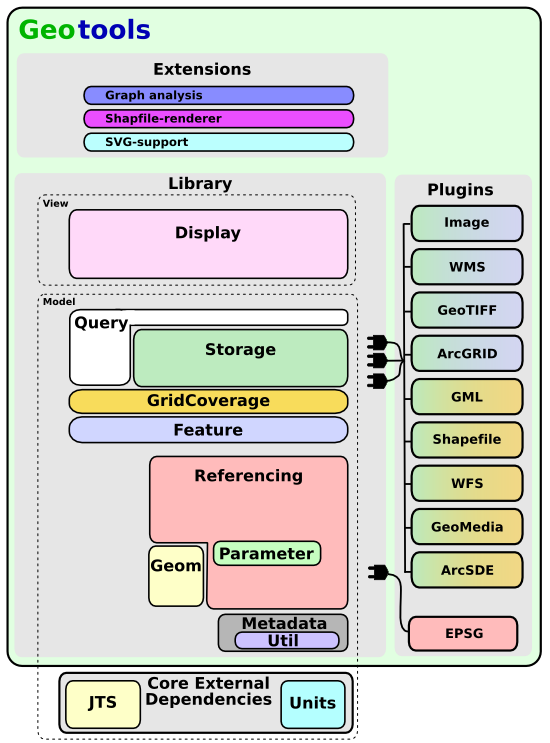
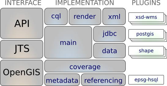
At its core, GeoTools excels in handling various geospatial data formats, including shapefiles, GeoJSON, KML, and more. This flexibility ensures seamless integration with existing datasets and workflows, making it an invaluable asset for developers working in diverse environments. The library's architecture is modular, allowing users to cherry-pick the components they need, thereby optimizing performance and resource utilization.
One of the standout features of GeoTools is its extensive support for Coordinate Reference Systems (CRS). The software includes a rich set of tools for transforming and projecting spatial data between different coordinate systems, ensuring that your data is always accurately represented. This capability is crucial for applications that require precise geolocation and mapping, such as environmental monitoring, urban planning, and navigation systems.
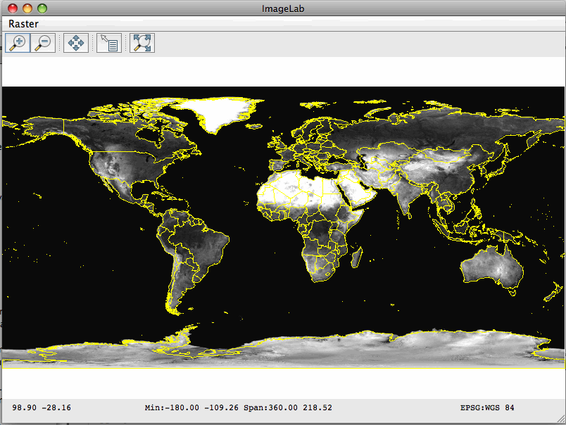
GeoTools also boasts a powerful rendering engine that can produce high-quality maps and visualizations. The rendering capabilities are highly customizable, enabling developers to create visually appealing and informative maps tailored to their specific needs. Whether you're building a web-based mapping application or a desktop GIS tool, GeoTools provides the rendering prowess needed to bring your spatial data to life.
In addition to its core functionalities, GeoTools is backed by a vibrant and active community. This community-driven approach ensures continuous improvement and innovation, with regular updates and a wealth of resources available for users. The extensive documentation, tutorials, and example projects make it easy for newcomers to get up to speed, while the active forums and mailing lists provide a platform for experienced users to share insights and collaborate.
GeoTools is also designed with interoperability in mind. It plays well with other geospatial libraries and tools, such as GDAL and JTS, allowing developers to leverage the strengths of multiple libraries within a single project. This interoperability extends to various programming languages through bindings and wrappers, making GeoTools a versatile choice for multi-language development environments.
Security and reliability are paramount in geospatial applications, and GeoTools does not disappoint. The software is rigorously tested and adheres to industry standards, ensuring that your applications are built on a solid foundation. The open-source nature of GeoTools also means that the code is transparent and subject to peer review, further enhancing its reliability and security.
In summary, GeoTools by GeoTools is a comprehensive and flexible geospatial Java library that stands out for its robust data handling, extensive CRS support, powerful rendering capabilities, and strong community backing. Whether you're a seasoned GIS professional or a developer new to the geospatial realm, GeoTools provides the tools and resources needed to build sophisticated and reliable geospatial applications.
Release notes:
New Release
Bug:
GEOT-7127 Error in read empty DBF
GEOT-7528 GeoPackage: Timestamp is not written correctly
GEOT-7537 GeoPackage TIMESTAMP must be DATETIME according to the GeoPackage spec
GEOT-7539 The latest tutorials link is broken in https://docs.geotools.org/
GEOT-7540 startIndex parameter is not passed in WFS store request
GEOT-7569 throw error while adding feature to FlatGeobuf featureStore
GEOT-7579 FlatGeobuf handle java.util.Date and iso correctness
GEOT-7589 Fix the JsonArrayDelegation for Postgres to support searching in root level array
GEOT-7590 Patterns containing "&" are broken when using LikeFilter
GEOT-7596 Reduce change of white line artifacts when performing high subsampling on read
GEOT-7611 WMS Client throws an ArrayIndexOutOfBoundsException when parsing attribution logoUrl element in invalid capabilities XML
GEOT-7626 ReferencedEnvelope CRS compatibility check is not recognizing equivalent ProjectedCRS. (identity transformation between source and target CRS)
GEOT-7642 some modules rely on transitive version of units-api
Improvement:
GEOT-7422 Update java units "indriya" to version 2.2
GEOT-7546 Add AUTO code (97004) for Geostationary satellite projection
GEOT-7548 Renovate arcgisrest with dependency updates and code formatting
GEOT-7550 Try harder to reproject envelopes with projections having a complex valid area
GEOT-7557 Provide the ability for downstream applications (e.g. GeoServer) to append additional querystring parameters e.g. AuthKey to every request made by the HTTPClient
GEOT-7558 GeoPackage extension output contains field types that are not supported by GDAL
GEOT-7561 Proposal: Individual contributor clarification
GEOT-7565 Upgrade ImageIO-Ext to 1.4.10
GEOT-7571 Support updates for PostgreSQL json/jsonb columns
GEOT-7576 Make SchemaCache use the HttpClient from the GeoTools hints
GEOT-7586 GeoPackage output contains invalid field types when publishing content from other JDBCDataStore
GEOT-7614 support for postgres reWrite
[
GeoTools full changelog ]
GeoTools 32.0 Free Download Notice
Top 4 Download periodically updates software information of GeoTools 32.0 full version from the publisher,
but some information may be slightly out-of-date.
Using warez version, crack, warez passwords, patches, serial numbers, registration codes, key generator, pirate key, keymaker or keygen for
GeoTools 32.0 license key is illegal and prevent future development of
GeoTools 32.0. Download links are directly from our mirrors or publisher's website,
GeoTools 32.0 torrent files or shared files from free file sharing and free upload services,
including Rapidshare, HellShare, HotFile, FileServe, MegaUpload, YouSendIt, SendSpace, DepositFiles, Letitbit, MailBigFile, DropSend, MediaMax, LeapFile, zUpload, MyOtherDrive, DivShare or
MediaFire,
are not allowed!
Your computer will be at risk getting infected with spyware, adware, viruses, worms, trojan horses, dialers, etc
while you are searching and browsing these illegal sites which distribute a so called keygen, key generator, pirate key, serial number, warez full version or crack for
GeoTools 32.0 download. These infections might corrupt your computer installation or breach your privacy.
A keygen or key generator might contain a trojan horse opening a backdoor on your computer.
Hackers can use this backdoor to take control of your computer, copy data from your computer or to use your computer to distribute viruses and spam to other people.